
FUNDING for the Exe Estuary Cycle Path and the final route for several sections have been agreed by Devon County Council's executive.
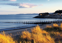
Forming an important part of the National Cycle Network, to the west of the estuary it will extend the existing network from Bridge Road in Exeter via Turf Lock, Powderham Church, Starcross and Cockwood to existing facilities in Dawlish Warren, which will then continue to Dawlish. East of the estuary it will connect Exmouth to Exeter.
The project is being carried out in nine separate sections during the next four years at a cost of £4.9 million. Funding of £1.45million has been allocated this financial year. The section beside the Exeter Canal from the M5 overbridge to Turf Lock will run along the existing maintenance track below the main canal embankment to avoid potential disturbance to wildlife.
This already has planning permission and is being constructed by Exeter City Council with the county council making a contribution of £172,500 towards the cost. Work began on this part in February this year. Plans for the section from Turf Lock to Powderham Church will be reported to a future meeting of the executive. Traffic calming measures will be necessary for the on-road section from Powderham Church to Starcross station. From Powderham Church the proposed route follows the existing estuary side road, which has no speed limit, and is approximately four metres wide for most of its length. Most of the A379 through Kenton is subject to 40mph and 30mph limits and drivers trying to avoid slow-moving vehicles travelling on the main road use the estuary side road inappropriately, said the county.


Traffic calming measures would reduce the attractiveness of this route for car drivers as a 'rat run' and provide greater safety for walkers and cyclists. The proposals will not jeopardise the use of the road as part of traffic management measures if there were an incident at Kenton, or when large events are held at the Powderham Estate.
The proposed measures include the remodelling of the southern Y junction at Exeleigh to form a T layout, plus the introduction of carriageway narrowing using traffic islands and road markings. When this work is complete, traffic speeds will be monitored and, if necessary, the 30mph speed restriction will be extended along the full length of the estuary side road as far as Powderham Church.
From Exeleigh, the cycle path will run parallel to the railway through the open grassed area as far as the Atmospheric Inn car park. This section already has planning permission. South of the Atmospheric Inn, some paved areas that are public highway will have to be remodelled. The layout will provide cycle parking, seating and landscaping near the public toilets with waiting restrictions on a new lay-by to allow for use of the local facilities. The pelican crossing will be upgraded to a toucan at the station.
From Starcross station to Eastdon, a short length of shared use footway will connect the upgraded toucan crossing to Bonhay Road. The route will then follow the minor road network: Wells Street, Courtney Terrace through to Royal Way. At the A379, the minor side road element of the junction will be remodelled to allow easier crossing of Royal Way by walkers and cyclists before they continue south along a new widened shared use path past properties fronting the main road. It will be necessary to remove the stonewall flanking the existing footway to provide sufficient space for shared use.
Once past the built-up area, the existing ditch line to the west of the road will be relocated further west as the route continues past Oak Meadow Golf Club. Reeds will be planted to minimise disturbance to wintering birds. The path will then go west behind the existing hedge line within the adjacent field all the way to the junction at Cockwood of the A379 and New Road.
A new toucan crossing is proposed to provide a safe crossing of the A379 for users. To the south this will connect via a short length of shared use path to the Dawlish Warren road into Cockwood. The crossing layout includes extending the footway on the south side and a greater width of hardened verge between the existing layby and the top of the slipway providing safer pedestrian access. Through Cockwood, the route follows the existing highway to the southern edge of the village, then the existing footway parallel to the railway, which will be widened to provide a shared-use path towards Eastdon. The final section from Eastdon to Dawlish Warren will be discussed at a future meeting of the executive. Teignbridge Council has set up a review group to help examine the key issues affecting cycling in the district. Those interested in getting involved can do so by contacting Dan Looker in Democratic Services on 01626 215111.